


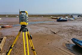
 Using the latest geomatic technology including; reflectorless theodolites, robotic instruments,
survey quality GPS and one-man total stations we provide our clients and their consultants with
accurate and economical survey solutions for all aspects of land surveying. Our software can
produce data in any format, including Autocad, for all measured land survey types including;
3D digital terrain models, DTM, volume or area calculations, sections and setting-out schedules.
Our land survey services are provided throughout the Kuwait and gulf region. Whether you
require assistance with topographical, engineering, boundaries or GPS survey we have the
Survey Solutions..
Using the latest geomatic technology including; reflectorless theodolites, robotic instruments,
survey quality GPS and one-man total stations we provide our clients and their consultants with
accurate and economical survey solutions for all aspects of land surveying. Our software can
produce data in any format, including Autocad, for all measured land survey types including;
3D digital terrain models, DTM, volume or area calculations, sections and setting-out schedules.
Our land survey services are provided throughout the Kuwait and gulf region. Whether you
require assistance with topographical, engineering, boundaries or GPS survey we have the
Survey Solutions..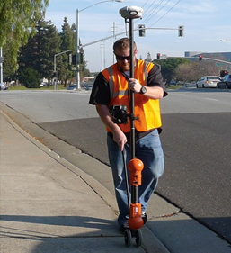 Vision use both non-intrusive investigations and direct access survey methods to provide a clear
understanding of buried services, utilities and hazards necessary for many aspects of construction
projects. This data reduces the need for expensive excavations or delays by identifying safe and
clear areas for all excavations, boreholes, piles and trial pits. Preparation of detailed digital
CAD drawings based on accurate topographical/land survey information can be essential at the
detailed design stage to use or avoid existing underground utilities, drainage networks and
obstructions and plan new services more efficiently. All our underground survey teams are fully
trained and equipped with the latest technology including multi-frequency electro-magnetic
equipment, CCTV drainage cameras and dual-frequency Ground Penetrating Radar (GPR).
Vision use both non-intrusive investigations and direct access survey methods to provide a clear
understanding of buried services, utilities and hazards necessary for many aspects of construction
projects. This data reduces the need for expensive excavations or delays by identifying safe and
clear areas for all excavations, boreholes, piles and trial pits. Preparation of detailed digital
CAD drawings based on accurate topographical/land survey information can be essential at the
detailed design stage to use or avoid existing underground utilities, drainage networks and
obstructions and plan new services more efficiently. All our underground survey teams are fully
trained and equipped with the latest technology including multi-frequency electro-magnetic
equipment, CCTV drainage cameras and dual-frequency Ground Penetrating Radar (GPR).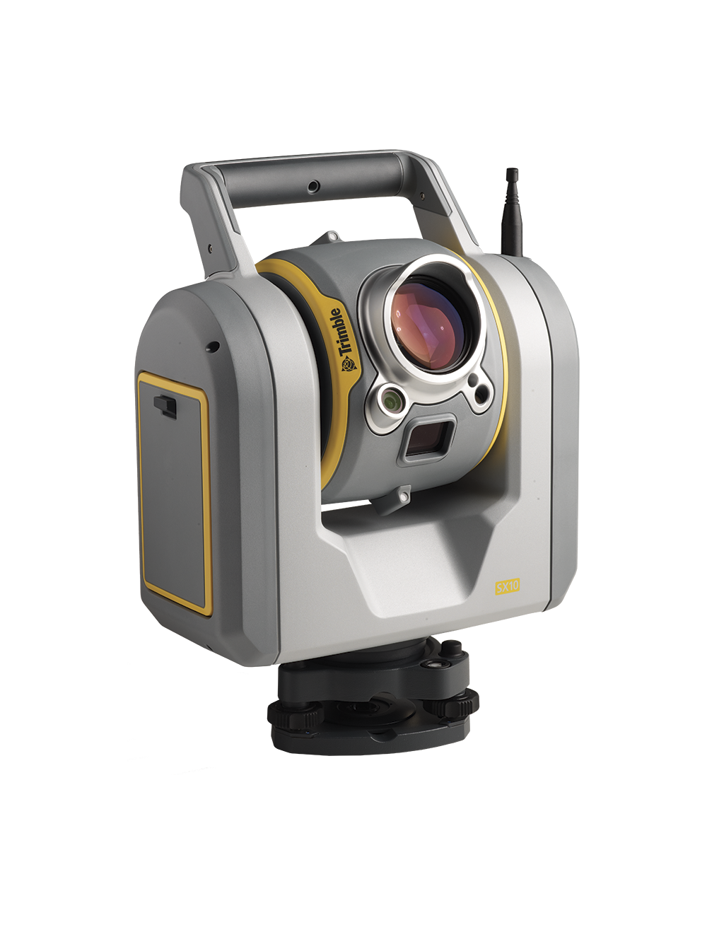 A Revolution in 3D Scanning the laser scanners are changing the way the industry looks at 3D.
Both capture high quality scans at exceptionally high speeds as they deliver superior accuracy
and range. Users now have more options to choose from to handle a wider range of projects with
the same, powerful Trimble Lightning technology, making our laser scanners the best values on
the market. Once the fieldwork is done, rely on Trimble RealWorks software to efficiently,
effectively manage large data sets and produce compelling deliverables.
A Revolution in 3D Scanning the laser scanners are changing the way the industry looks at 3D.
Both capture high quality scans at exceptionally high speeds as they deliver superior accuracy
and range. Users now have more options to choose from to handle a wider range of projects with
the same, powerful Trimble Lightning technology, making our laser scanners the best values on
the market. Once the fieldwork is done, rely on Trimble RealWorks software to efficiently,
effectively manage large data sets and produce compelling deliverables. Mobile Laser Scanning (MLS), also known as Mobile LiDAR (Light Detection and Ranging), is a
remote sensing technique used to collect highly accurate 3D spatial data of the surrounding
environment from a moving platform, such as a vehicle or aircraft.
Mobile Laser Scanning (MLS), also known as Mobile LiDAR (Light Detection and Ranging), is a
remote sensing technique used to collect highly accurate 3D spatial data of the surrounding
environment from a moving platform, such as a vehicle or aircraft.
 Vision International uses a number of aerial
imagery acquisition platforms to provide
mapping at various scales and formats for clients,
according to their requirements.
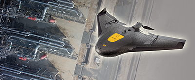
Using a Trimble UX5 Unmanned Aerial Vehicle (UAV)
based in Kuwait, Vision International is able to respond
rapidly to requests for the flying of aerial
photography, with the height of flying determining
the scale and accuracy of the resultant mapping.
Deliverables to the client can be either Digital Terrain
Models ( DTM ) , or rectified orthophotos, or full,
contoured topographic mapping. The use of the UAV
makes the preparation and updating of base mapping
for Geographical Information Systems easy, accurate
and fast, responding immediately to requests
by clients.
The company also has a formal agreement with IIC
Technologies, an international surveying company
with offices globally, for the flying of aerial photography
using their own aircraft, using an Intergraph
DMC II230 digital camera.
Vision International uses a number of aerial
imagery acquisition platforms to provide
mapping at various scales and formats for clients,
according to their requirements.
Using a Trimble UX5 Unmanned Aerial Vehicle (UAV)
based in Kuwait, Vision International is able to respond
rapidly to requests for the flying of aerial
photography, with the height of flying determining
the scale and accuracy of the resultant mapping.
Deliverables to the client can be either Digital Terrain
Models ( DTM ) , or rectified orthophotos, or full,
contoured topographic mapping. The use of the UAV
makes the preparation and updating of base mapping
for Geographical Information Systems easy, accurate
and fast, responding immediately to requests
by clients.
The company also has a formal agreement with IIC
Technologies, an international surveying company
with offices globally, for the flying of aerial photography
using their own aircraft, using an Intergraph
DMC II230 digital camera.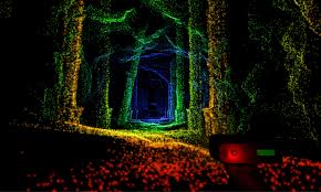 LiDAR scanning provides a highly accurate and efficient means of capturing the detailed geometry of
structures. Its applications in structural engineering are vast, enabling precise assessments,
documentation, and planning. If you have specific projects or issues you’re working on.
LiDAR scanning provides a highly accurate and efficient means of capturing the detailed geometry of
structures. Its applications in structural engineering are vast, enabling precise assessments,
documentation, and planning. If you have specific projects or issues you’re working on.